Log in
All resources
Create a design
673 Free Images of Geographical Distribution
pictorial works
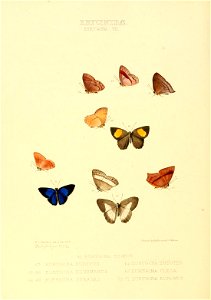
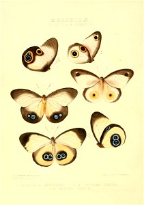
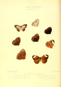
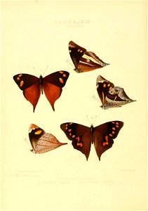
butterfly
lepidoptera
speciation
smithsonian libraries
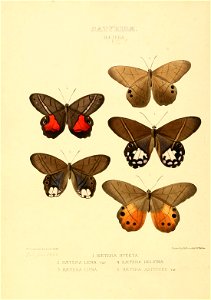
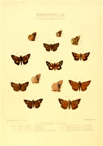
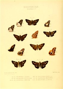
illustrations of new species of exotic butterflies : selected chiefly from the collections of w. wilson saunders and william c. hewitson v.4 (1867-1871)
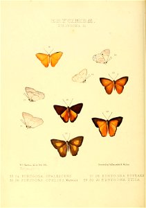
illustrations of new species of exotic butterflies : selected chiefly from the collections of w. wilson saunders and william c. hewitson v.5 (1872-1876)
lepidoptera
butterfly
lepidoptera
butterfly
lepidoptera
butterfly
lepidoptera
butterfly
lepidoptera
butterfly
lepidoptera
butterfly
lepidoptera
butterfly
lepidoptera
butterfly
lepidoptera
butterfly
lepidoptera
butterfly
lepidoptera
butterfly
lepidoptera
butterfly
lepidoptera
butterfly
lepidoptera
butterfly
lepidoptera
butterfly
lepidoptera
butterfly
lepidoptera
butterfly
lepidoptera
butterfly
lepidoptera
butterfly
lepidoptera
butterfly
lepidoptera
butterfly
lepidoptera
butterfly
lepidoptera
butterfly
lepidoptera
butterfly
lepidoptera
butterfly
lepidoptera
butterfly
lepidoptera
butterfly
lepidoptera
butterfly
lepidoptera
butterfly
lepidoptera
butterfly
lepidoptera
butterfly
lepidoptera
butterfly
lepidoptera
butterfly
lepidoptera
butterfly
lepidoptera
butterfly
lepidoptera
butterfly
lepidoptera
butterfly
lepidoptera
butterfly
lepidoptera
butterfly
lepidoptera
butterfly
lepidoptera
butterfly
lepidoptera
butterfly
lepidoptera
butterfly
lepidoptera
butterfly
lepidoptera
butterfly
lepidoptera
butterfly
lepidoptera
butterfly
lepidoptera
butterfly
lepidoptera
butterfly
lepidoptera
butterfly
lepidoptera
butterfly
lepidoptera
butterfly
lepidoptera
butterfly
lepidoptera
butterfly
lepidoptera
butterfly
lepidoptera
butterfly
lepidoptera
butterfly
lepidoptera
butterfly
lepidoptera
butterfly
lepidoptera
butterfly
lepidoptera
butterfly
lepidoptera
butterfly
lepidoptera
butterfly
lepidoptera
butterfly
lepidoptera
butterfly
lepidoptera
butterfly
lepidoptera
butterfly
lepidoptera
butterfly
lepidoptera
butterfly
lepidoptera
butterfly
lepidoptera
butterfly
lepidoptera
butterfly
lepidoptera
butterfly
africa
bird
lepidoptera
butterfly
lepidoptera
butterfly
lepidoptera
butterfly
lepidoptera
butterfly
lepidoptera
butterfly
lepidoptera
butterfly
lepidoptera
butterfly
lepidoptera
butterfly
lepidoptera
butterfly
lepidoptera
butterfly
lepidoptera
butterfly
lepidoptera
butterfly
lepidoptera
butterfly
lepidoptera
butterfly
lepidoptera
butterfly
lepidoptera
butterfly
lepidoptera
butterfly
lepidoptera
butterfly
lepidoptera
butterfly
lepidoptera
butterfly
lepidoptera
butterfly
lepidoptera
butterfly
lepidoptera
butterfly
lepidoptera
butterfly
lepidoptera
butterfly
lepidoptera
butterfly
301 - 400 of 673
Next page
/ 7